Insights

Nashville Moves Apace to Remake its East Bank

Under the framework of Perkins Eastman’s vision plan, Metro Nashville is acting with unusual speed to transform its shores across from downtown.
By Eric Fang, FAIA, AICP, LEED AP, Principal
Nashville East Bank Vision Plan rendering displaying gardens and green space cascading down toward the Cumberland River
Under Perkins Eastman's vision plan for Nashville's East Bank, a new Central Park cascades down from the football stadium toward the Cumberland River, with views toward the city's downtown skyline across the water. All renderings, diagrams, and photographs © Perkins Eastman

For an initiative the Metro Nashville Planning Department has called “one of the largest and most complex planning studies Nashville has undertaken,” it’s remarkable how quickly the city is moving to redevelop hundreds of acres of parking lots and an industrial landscape into a thriving, mixed-use destination. Many years remain before the entire vision for its East Bank riverfront is realized, but the plan is being implemented at a pace all but unheard of for a large, publicly led urban design project.

An aerial view of Nashville's East Bank depicts the details of a master plan to transform an industrial landscape into a mixed-use development.

Details of Perkins Eastman’s East Bank vision plan.

In 2023, just 18 months after the planning commission unanimously passed Imagine East Bank, which incorporates the vision plan Perkins Eastman developed to lay out four walkable neighborhood districts along the east bank of the Cumberland River, the Metropolitan Nashville Council unanimously approved an agreement to begin developing the first 30-acre parcel. And in 2024, the City established the East Bank Development Authority (EBDA), charged with promoting economic development along the East Bank of the Cumberland River. The planning commission also approved the development agreement for a domed stadium for the NFL’s Tennessee Titans, which will anchor the initial development. It is currently topped out and on track to open in 2027. The existing Nissan Stadium will be razed after the new stadium opens, making way for public plazas and cascading parkland that will flow to the river’s edge. The vision plan also provides a location for the Tennessee Performing Arts Center in this new district; TPAC is currently negotiating with the city on its relocation there.

A rendering of a plaza outside the new Nissan Stadium in Nashville, TN, which includes outdoor restaurants and bars.

The mixed-use development in the first parcels to be developed around the new stadium replaces the traditional notion of tailgating, moving people from their cars to parks surrounded by outdoor terraces, bars, and restaurants.

The East Bank plan is the latest of many waterfront master plans Perkins Eastman has become known for—notably The Wharf in Washington, DC, Baltimore Inner Harbor East, and Battery Park City in Manhattan. The celebrated Arverne by the Sea on Rockaway Beach in Queens, NY, has been studied for its resiliency, which enabled homes and businesses to survive largely intact after Superstorm Sandy in 2012 while nearby structures suffered widespread damage and destruction.

That’s why, in 2021, Perkins Eastman Principal Vaughan Davies and I kicked off the East Bank project with a boat ride along the Cumberland River. “We had to work with the water,” Davies says. Looking at land from the water, he adds, “makes you much more respectful of the power of the water—and the physical harm that can be done by this massive amount of water.”

A photograph shows Perkins Eastman consultants and Nashville city officials who boarded a fire department boat in 2021 to survey the East Bank from the water’s perspective.

Perkins Eastman consultants and Nashville city officials boarded a fire department boat in 2021 to survey the East Bank from the water’s perspective.

In 2010, the City of Nashville suffered unprecedented flooding from 36 hours of rainstorms that forced the Cumberland far over its banks, leaving 11,000 properties damaged or destroyed and causing more than $2 billion in private-property claims. It was the only storm to crest higher than the 100-year storm elevation that was set when the city began regulating the river in 1967. Concurrent with regulating a barren stretch of prime waterfront land directly across from the center of downtown Nashville, the East Bank plan had to organize development in a way that would manage stormwater at these historic levels. Parks and greenways for pedestrians and cyclists will double as flood plains, where underground infrastructure can store excess water before filtering it slowly down toward the river. Development parcels will be elevated above the flood plain, acting as levees to protect greater East Nashville. “We started with a water plan, not a land plan,” Davies explains.

This resiliency plan shows how development on Nashville's East Bank steps up in elevation towards the new Tennessee Titans stadium, while open space acts to slow, store, and filter stormwater back into the river to prevent flooding.

This resiliency plan shows how development steps up in elevation towards the new stadium, while open space acts to slow, store, and filter stormwater back into the river to prevent flooding.

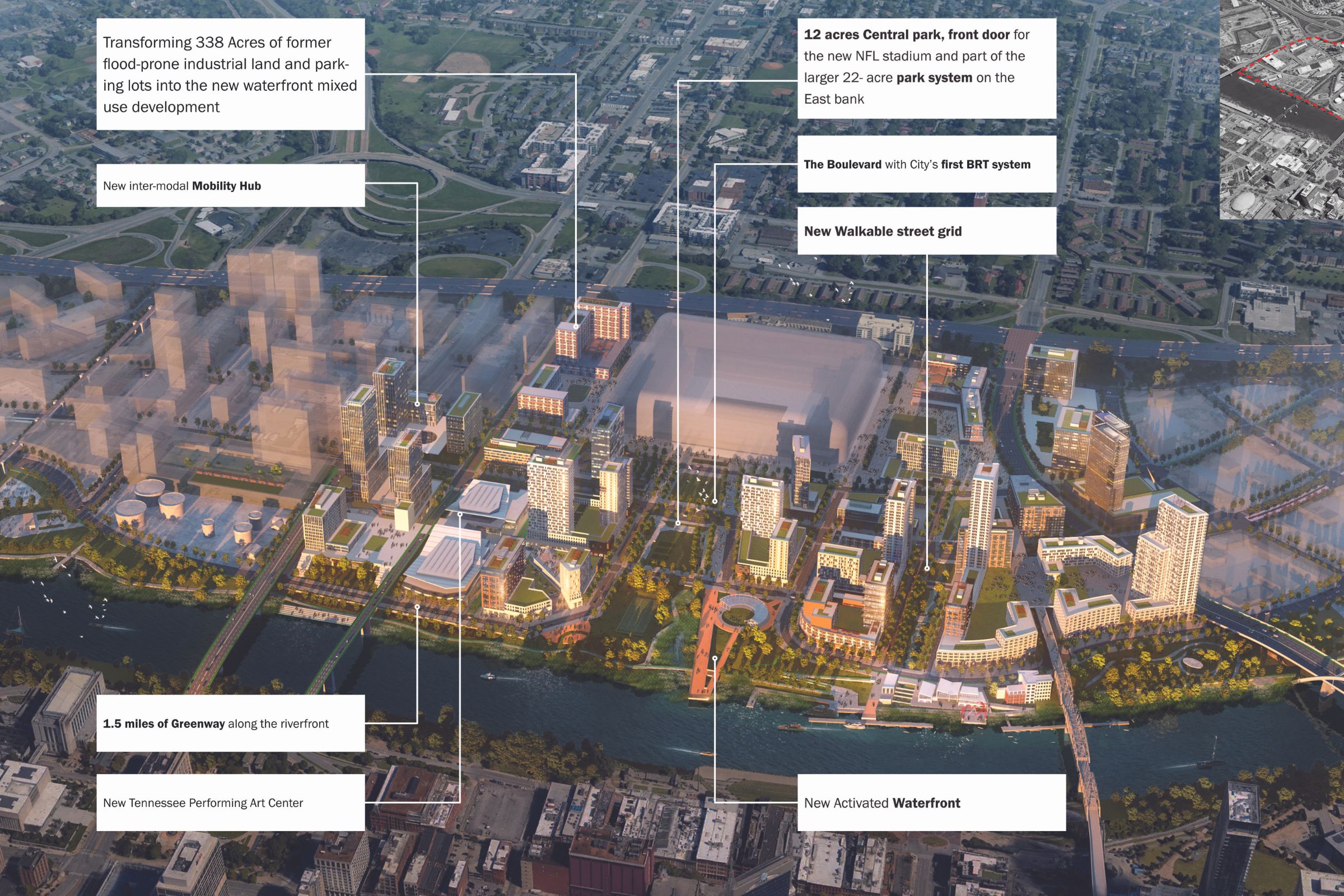
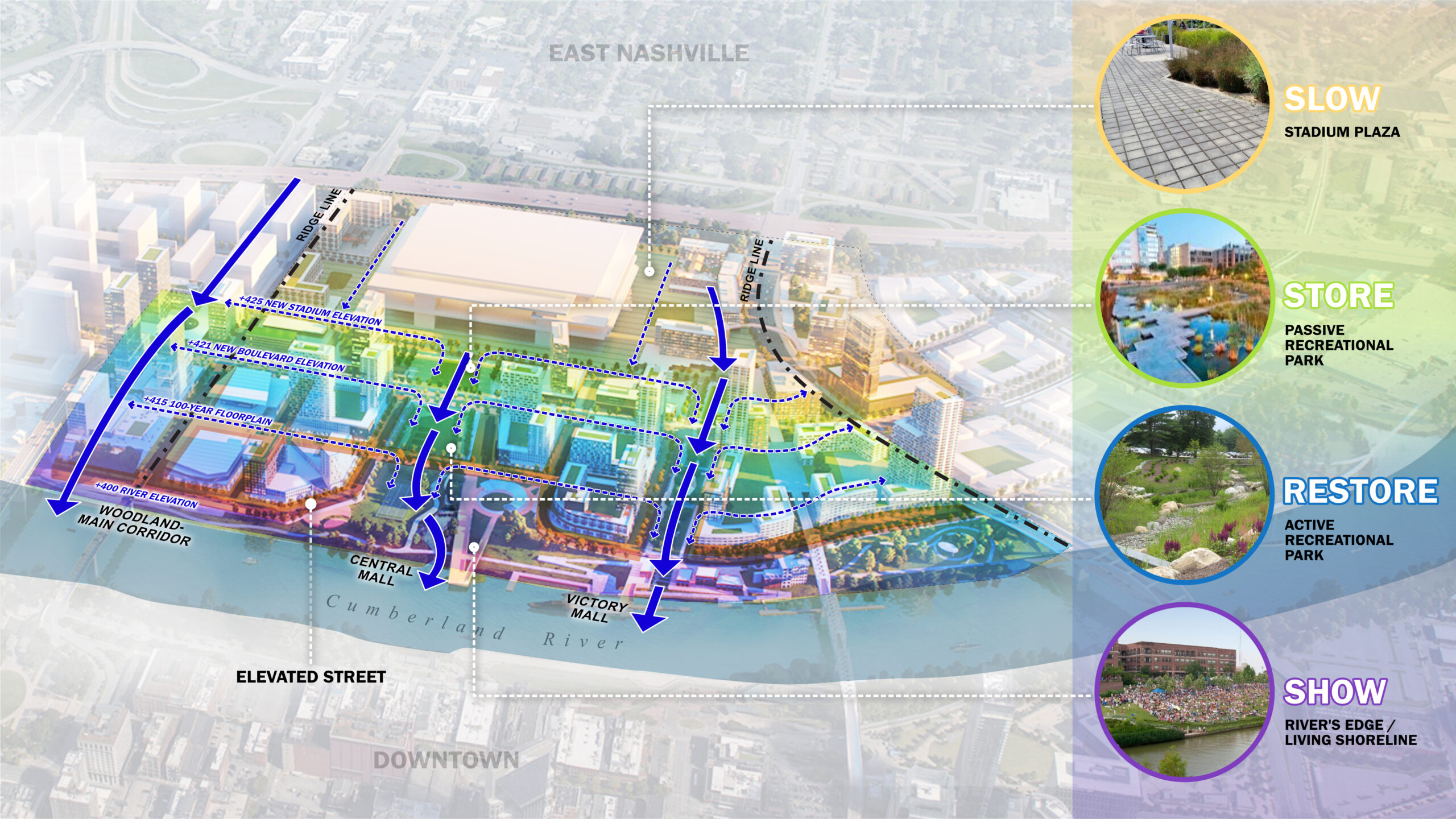
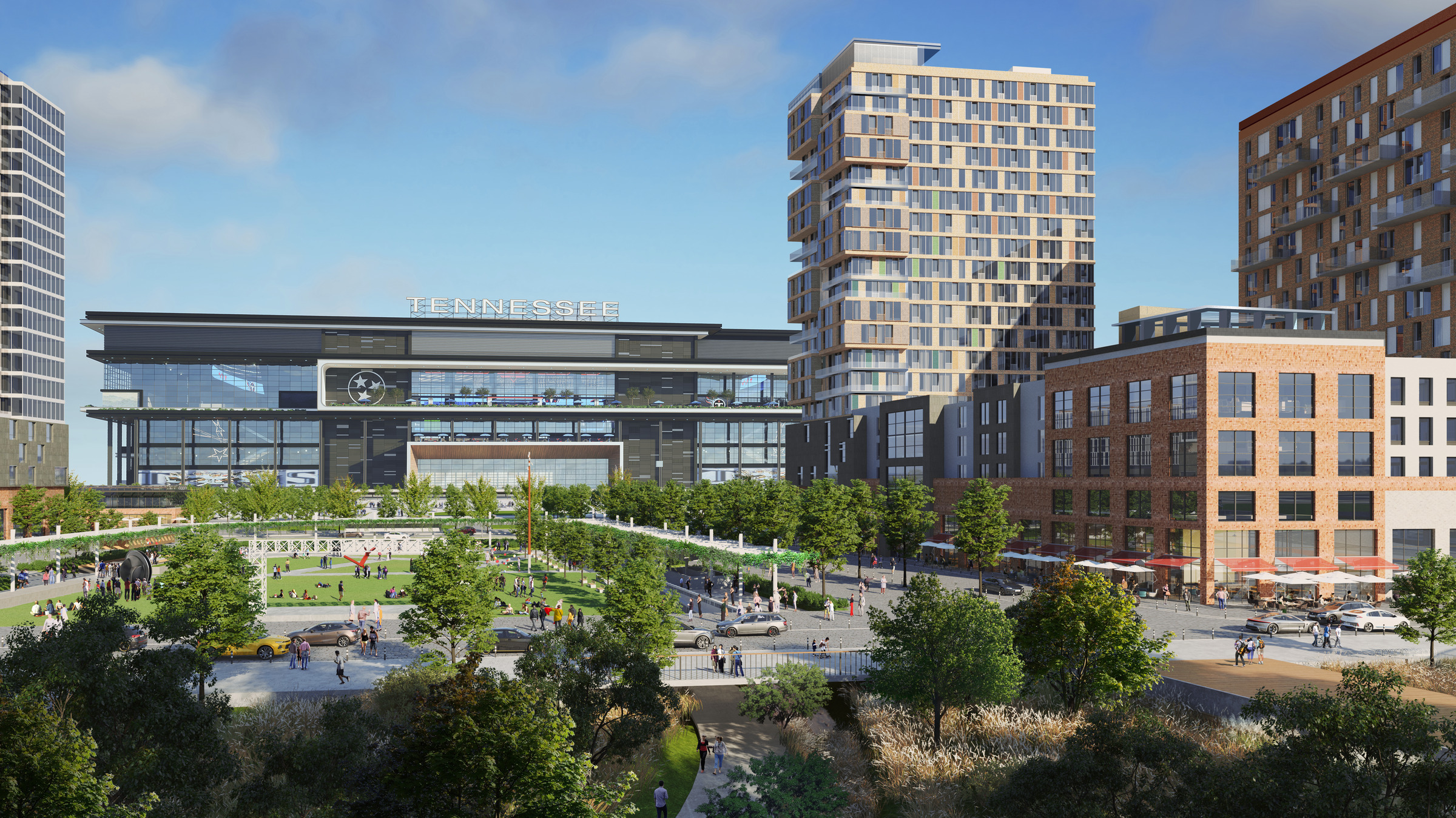
Transportation plays heavily into the plan as well—a large-scale vision that’s only possible because the city manages such a huge swath of the East Bank property, giving its planners a “blank slate” to work with. And that’s good, considering the current situation. “Driving from one end of Nashville’s East Bank to the other currently means navigating a disjointed network of streets around parking lots and industrial properties,” requiring at least five turns in the process, the Nashville Tennessean noted. The entire East Bank strip, which includes a large parcel Oracle intends to develop as its new headquarters and the River North district, where private landowners are developing hotels and residential buildings, “is today cut in half by the concrete wall of the James Robertson Parkway Bridge. Interstate 24 divides the East Bank from the more walkable streets of East Nashville,” the newspaper wrote.

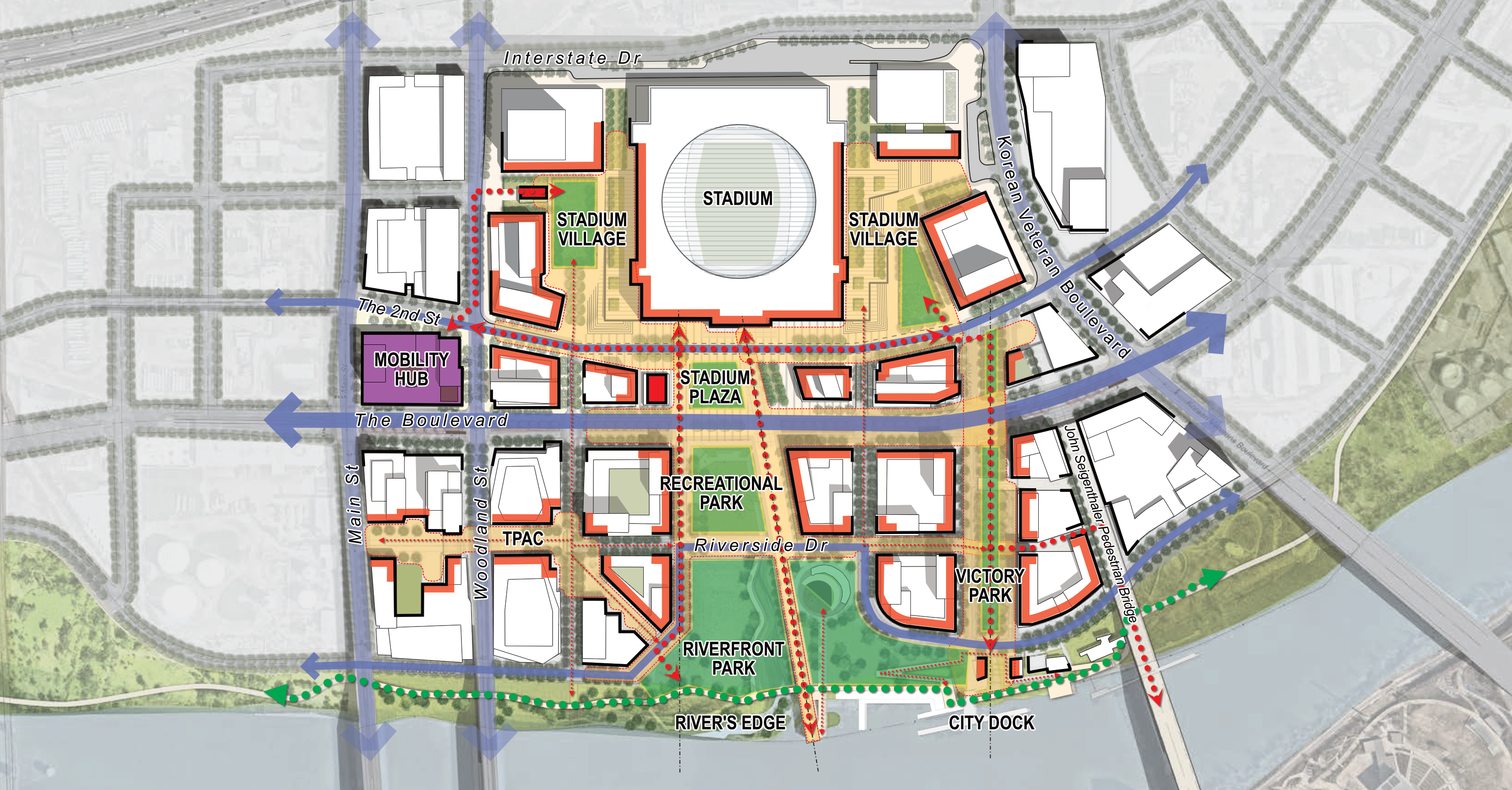
Perkins Eastman’s plan proposes bringing that bridge down to grade, rerouting a network of CSX freight tracks, and establishing a wide, straight boulevard—currently in design—as East Bank’s north-south spine, where pedestrians, cyclists, and buses, and cars will have equal access.

A rendering shows a new central boulevard that will act as the East Bank’s central artery for transit, auto, pedestrian, and bike traffic.

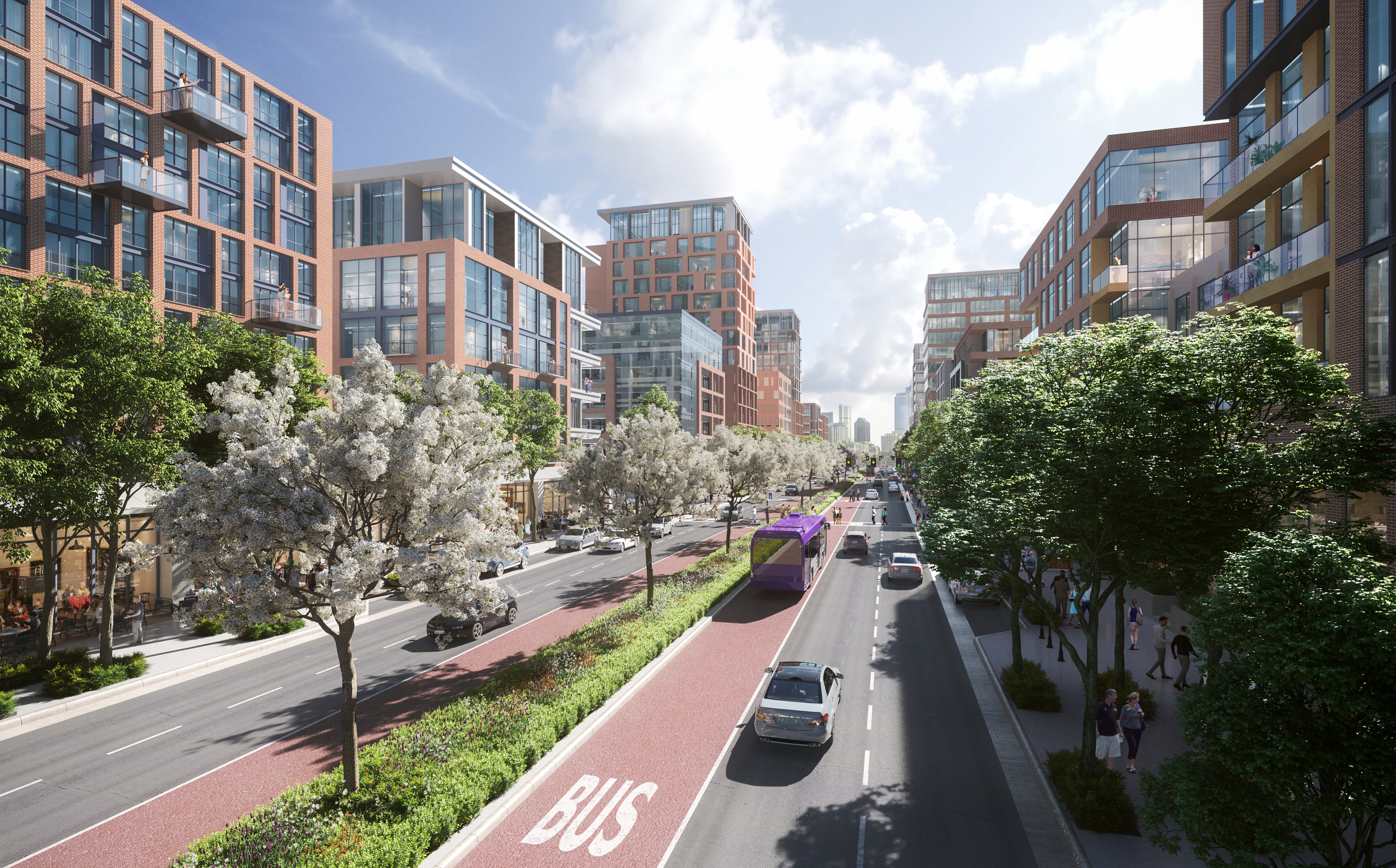
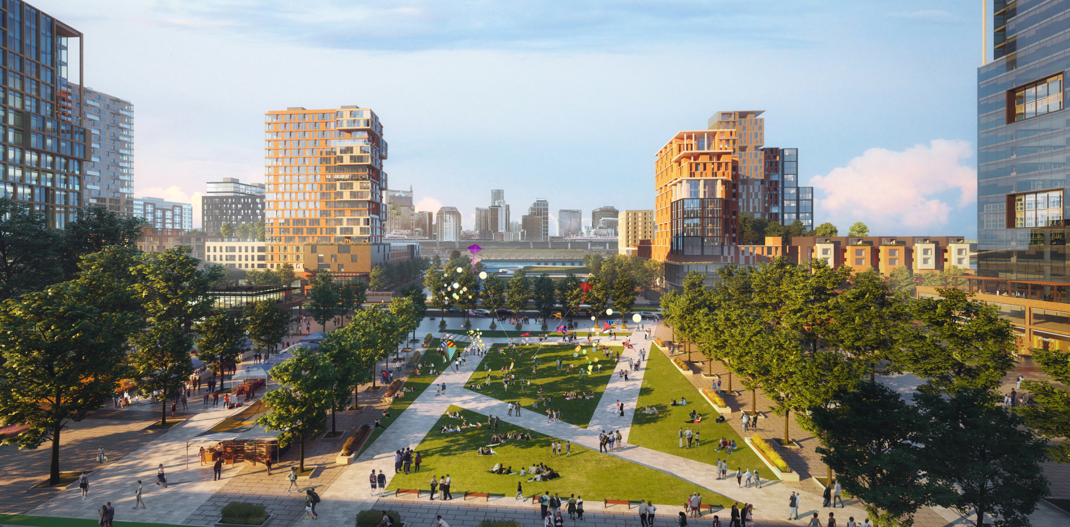
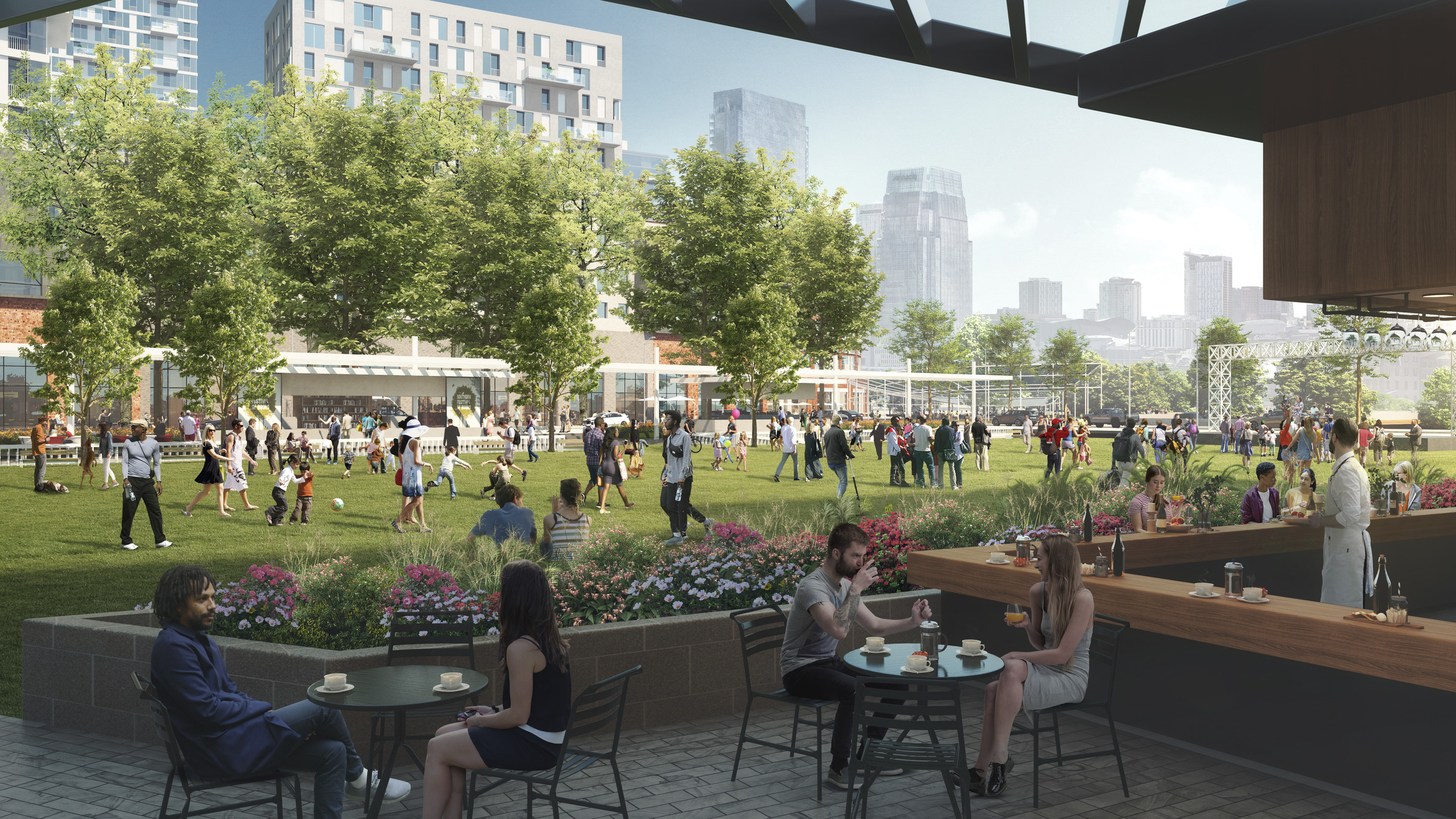
The Boulevard will act as the East Bank’s central artery for transit, auto, pedestrian, and bike traffic. “The Boulevard has to be, first and foremost, a public place for people,” Metro Planning Director Lucy Kempf told the Tennessean.

The existing John Seigenthaler Pedestrian Bridge over the river is also slated for an extension, while two car-dominated bridges will be recast to include pedestrian and bike lanes. A water taxi could also be in the offing to provide alternatives to people who might otherwise drive to the East Bank. A Mobility Hub transit center will be constructed to accommodate all types of multimodal connections.

A diagram illustrates Perkins Eastman's master plan to remake the East Bank of Nashville along the Cumberland River.l

The James Robertson Parkway Bridge will be brought down to street level along Main Street (on the left in Perkins Eastman’s East Bank plan, above). The plan calls for a new, walkable network of streets and greenways that intersect parks and new development across the 338-acre area.

Nashville East Bank rendering of the recreational and transportation dock. An illustration of the new greenway with a dedicated bike lane on Nashville's East Bank

With a new city dock, greenway trails that connect to the city’s existing network, and open green space, the East Bank plan will offer Nashville’s residents and visitors access to the Cumberland River that never previously existed. 

The public realm surrounding the new football stadium is also designed to reduce car dependence. Rather than swaths of asphalt parking lots, the new, mixed-use stadium will anchor a “stadium village” of residential, hotel, office, and retail that will frame public plazas and parks that are linked by the area’s multimodal network.

A rendering of Nashville East Bank shows development surrounding the new Tennessee Titans stadium includes residential buildings where at least 45 percent of the new units are slated to be affordable.

The development surrounding the new stadium includes residential buildings where around 45 percent of the new units are slated to be affordable.

Economic accessibility is just as important as physical access, as contemplated in the Imagine East Bank plan. The Boston-based Fallon Company is developing the first 30 acres on parcels surrounding the new stadium. The developer is required to provide 1,550 housing units over the next decade—and nearly 45 percent of them must be affordable. The first 300 units must all be affordable, based on the area’s median income, and include a childcare center.

Follow the city’s progress as the East Bank takes shape here, and learn more about the full scope of Perkins Eeastman’s plan here.