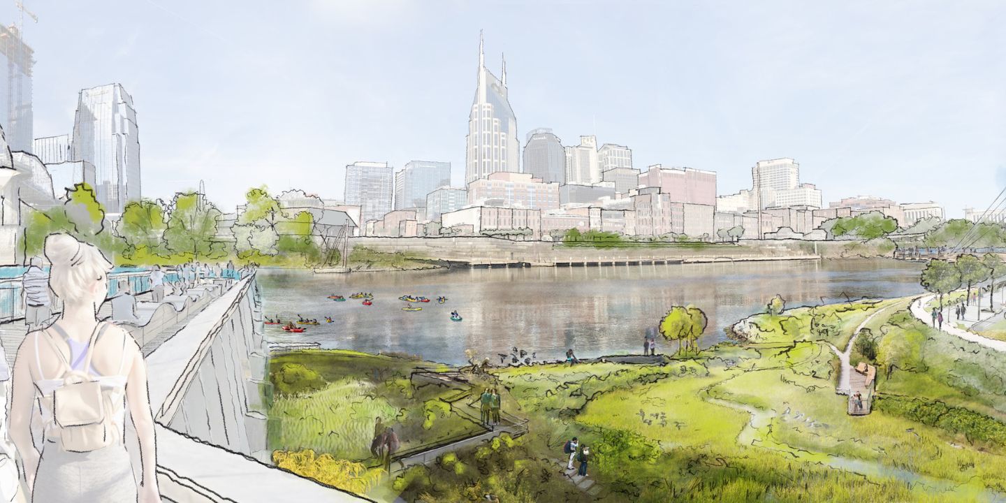
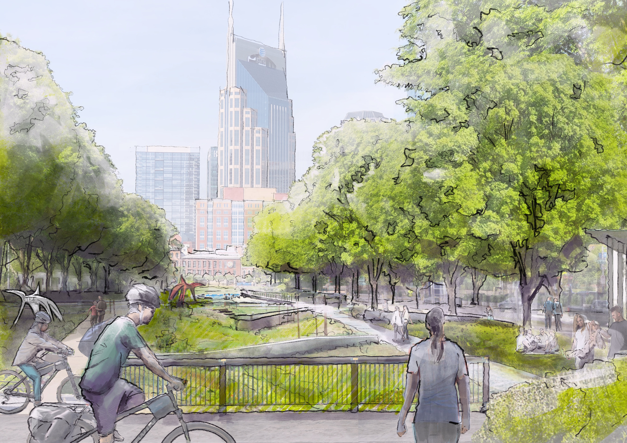
Black and white sketch of the newly envisioned Nashville East Bank

Nashville East Bank: A Case Study

Nashville, TN

Centrally located on the banks of the Cumberland River, East Bank represents a once-in-a-generation opportunity for the City of Nashville.

Project Facts

  • Client:

  • Metropolitan Government of Nashville and Davidson County
  • Size:

  • 338 acres
  • Services:

  • Master Planning, Urban Design, Resiliency, Implementation Strategy
  • Markets:

  • Large Scale Mixed-Use, Planning + Urban Design
  • Region:

  • United States
  • Studios:

  • New York, Los Angeles

    News

  • Read More

    Awards

  • 2024 Engineering Excellence National Recognition Award, ACEC Tennessee
  • 2023 Grand Award Winner in Large Project category, American Council of Engineering Companies Tennessee Engineering Excellence Awards
  • Nashville’s East Bank enjoys an enviable location along the banks of the Cumberland River, across from downtown’s central core with access to a major interstate highway and serving as home to the NFL’s Tennessee Titans. The current site, however, is a barren industrial landscape surrounding acres of stadium parking lots.

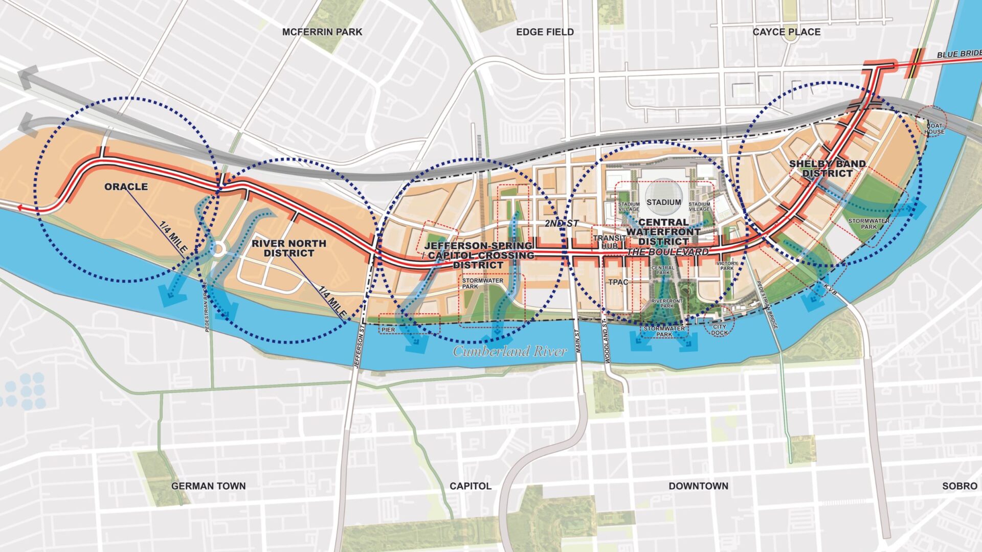
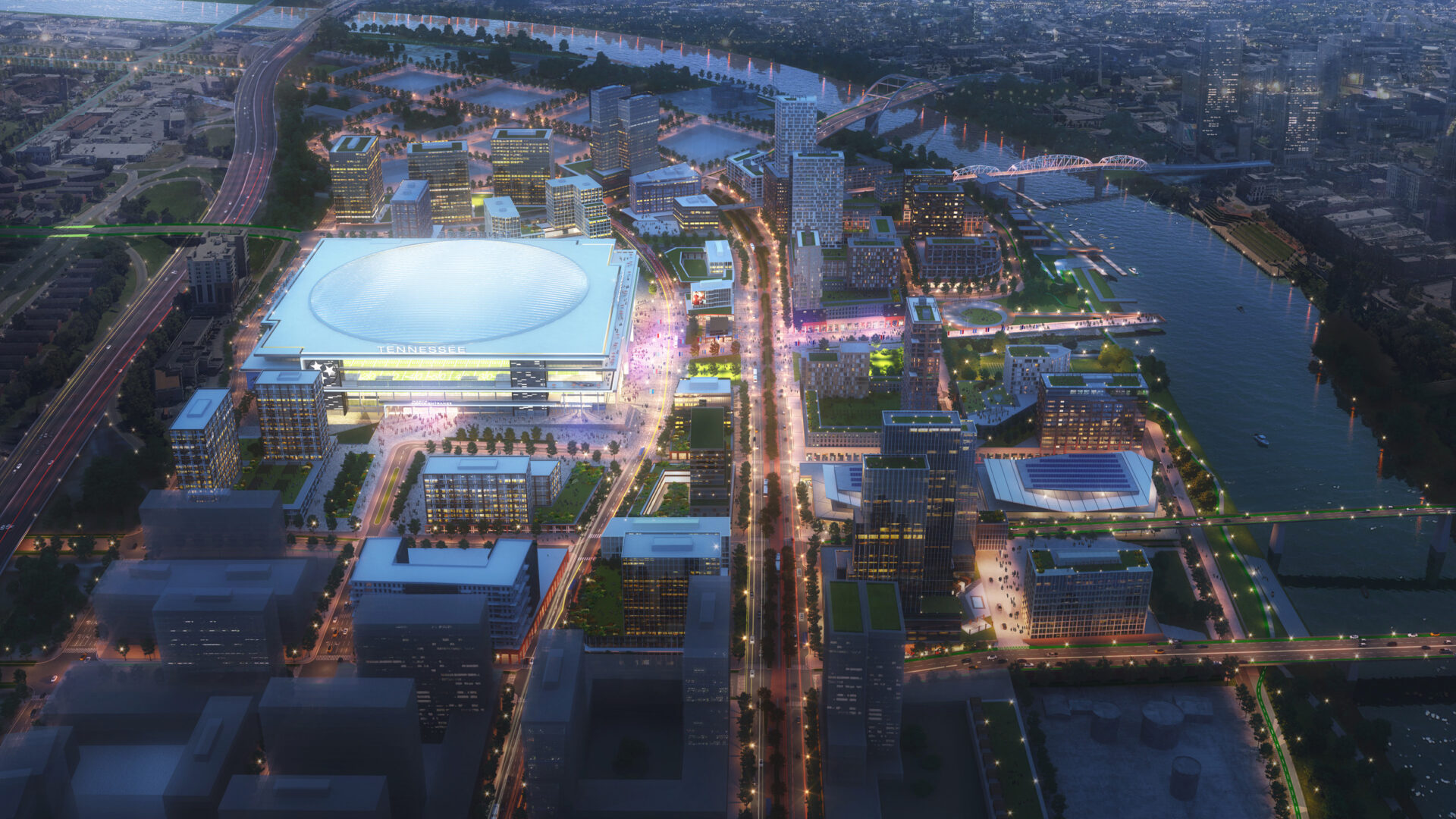
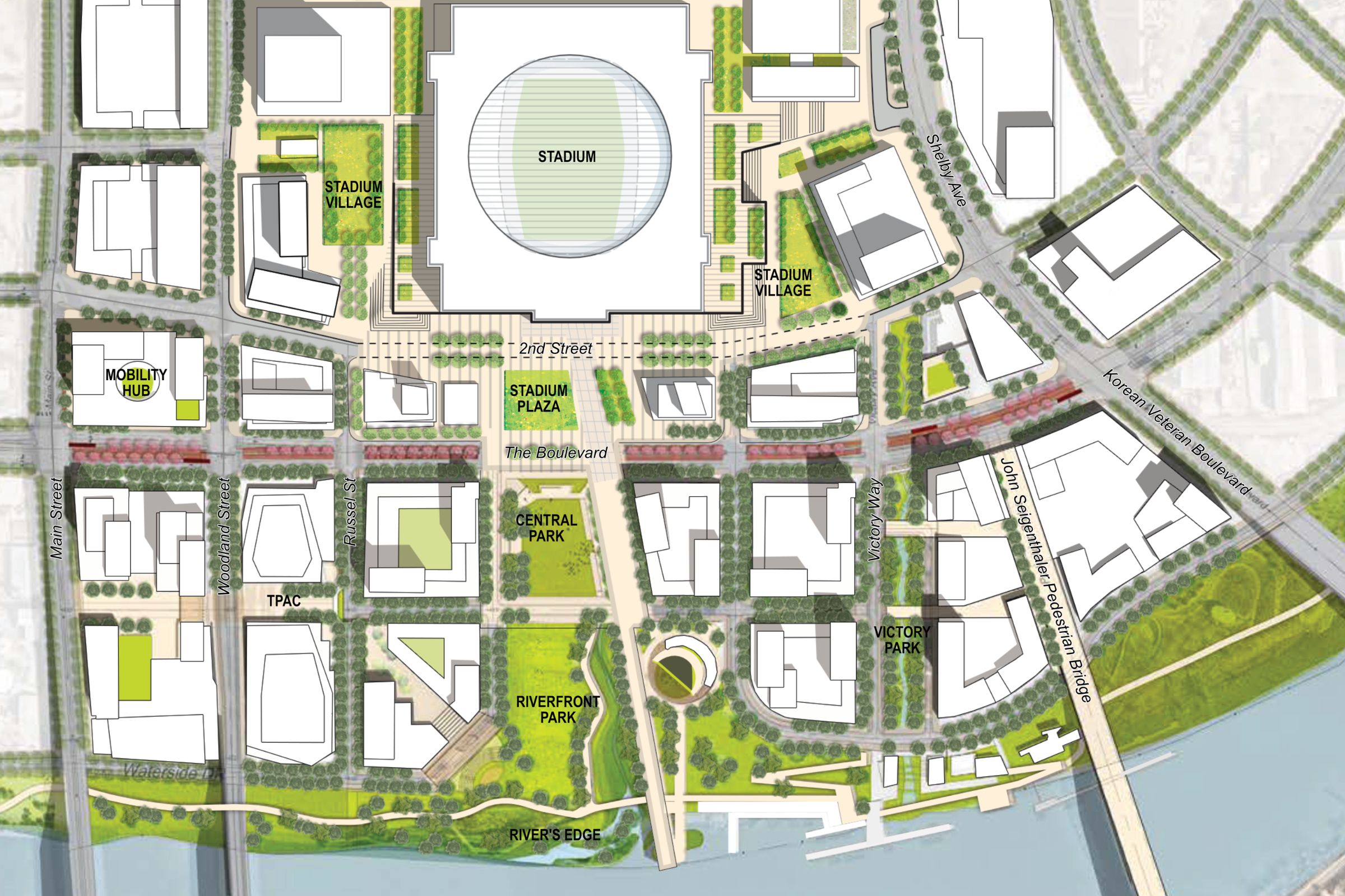
    The Nashville East Bank Plan envisions 22 million square feet of new mixed-use development across four walkable districts. It includes a new home for the Tennessee Performing Arts Center, a “Mobility Hub” transit center, 12 acres of parks, and a new domed football stadium at the heart of a “stadium village” in what will be the Central Waterfront District.

    The Cumberland River’s significance in Nashville’s history contrasts with the East Bank’s industrial past and its limited connectivity to the water. Ongoing revitalization seeks to restore the waterfront, bridge the East Bank-downtown gap, and foster community engagement, transforming the area into a vibrant, accessible, urban space.
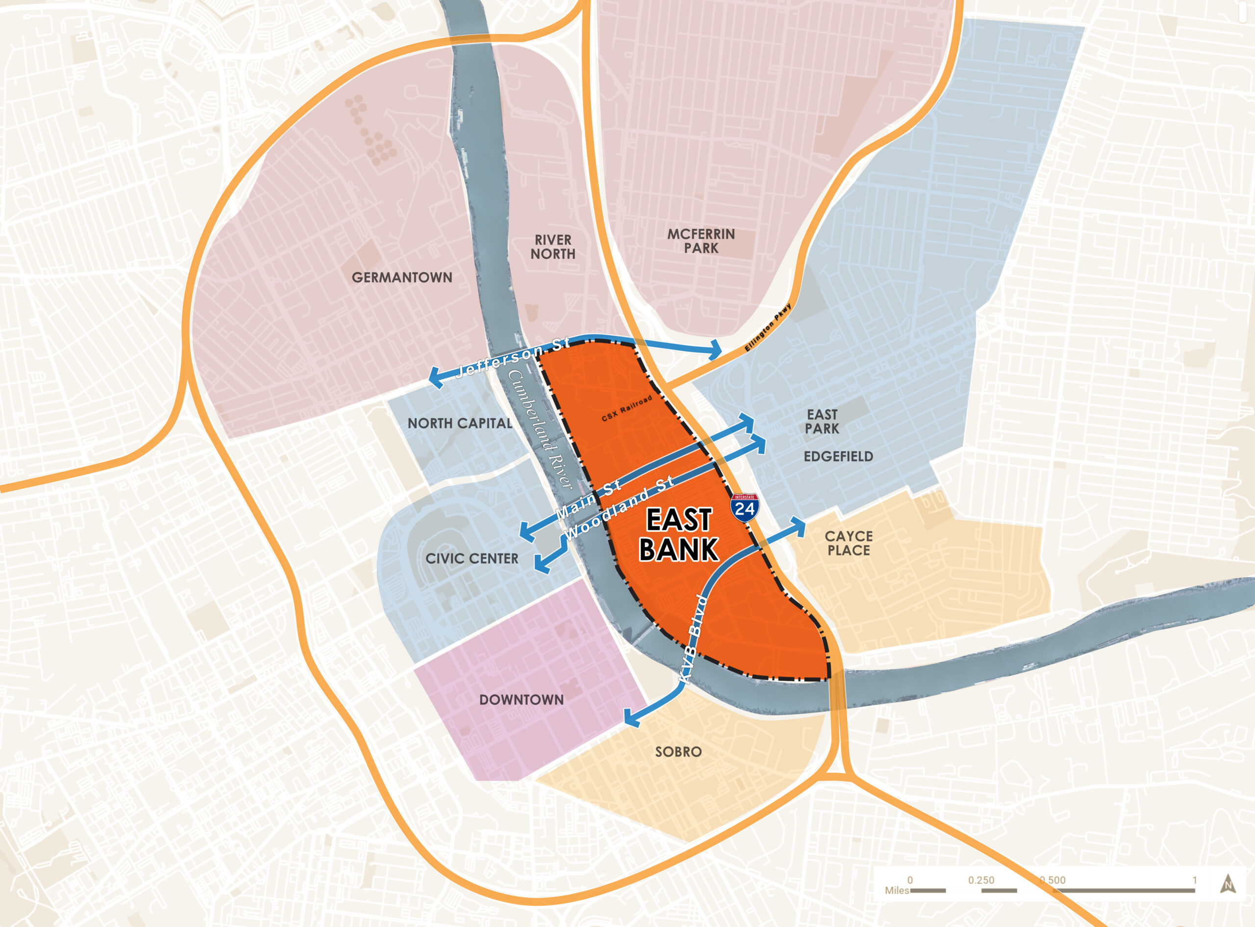
     

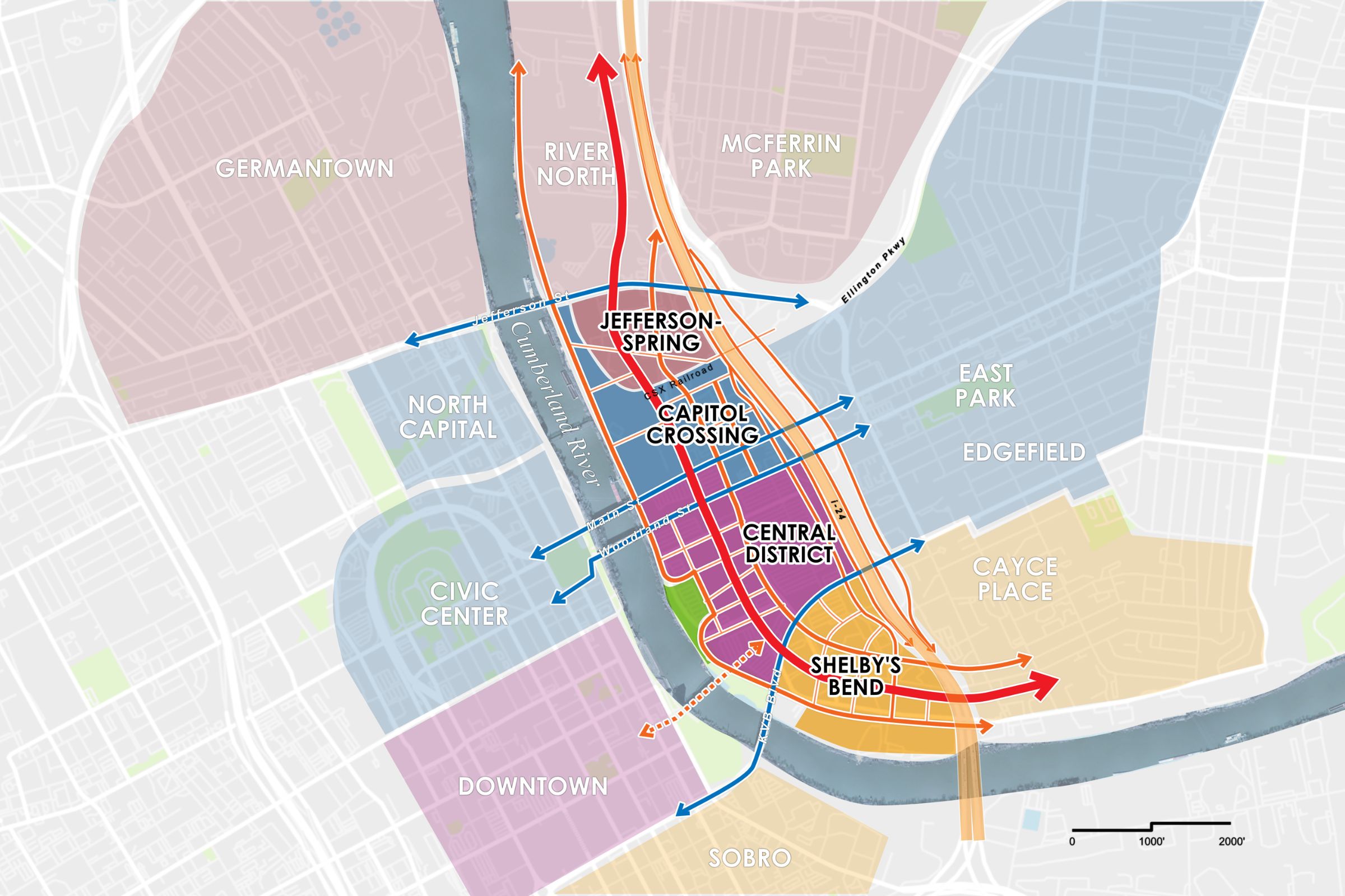
    A map of Nashville's East Bank, showing the four existing bridges that cross from it into the city's downtown core.

    Working closely with Nashville Metro Planning and Nashville DOT, and building on a robust stakeholder engagement program, Perkins Eastman developed a bold vision for the future of East Bank based on four principles:

    • A walkable street grid that works with existing properties and expands connections to regional transportation networks
    • A continuous riverfront park, opening up access to the Cumberland for residents of East Nashville for the first time
    • A one-and-a-half mile multi-modal boulevard featuring a dedicated lane for Bus Rapid Transit that will serve as the transportation spine for the entire East Bank
    • A comprehensive, district-scale strategy for enhancing the resiliency of the flood-prone area. which is integrated with the new open-space network
    Perkins Eastman Created a master plan for the East Bank of the Cumberland River that runs through central Nashville. The plan addresses city-owned property to the south of Jefferson Street; Oracle is establishing a new headquarters campus to the north, while private interests are planning development in the River North District
    Perkins Eastman Created a master plan for the East Bank of the Cumberland River that runs through central Nashville. The plan addresses city-owned property to the south of Jefferson Street; Oracle is establishing a new headquarters campus to the north, while private interests are planning development in the River North District | All graphics and renderings ©Perkins Eastman

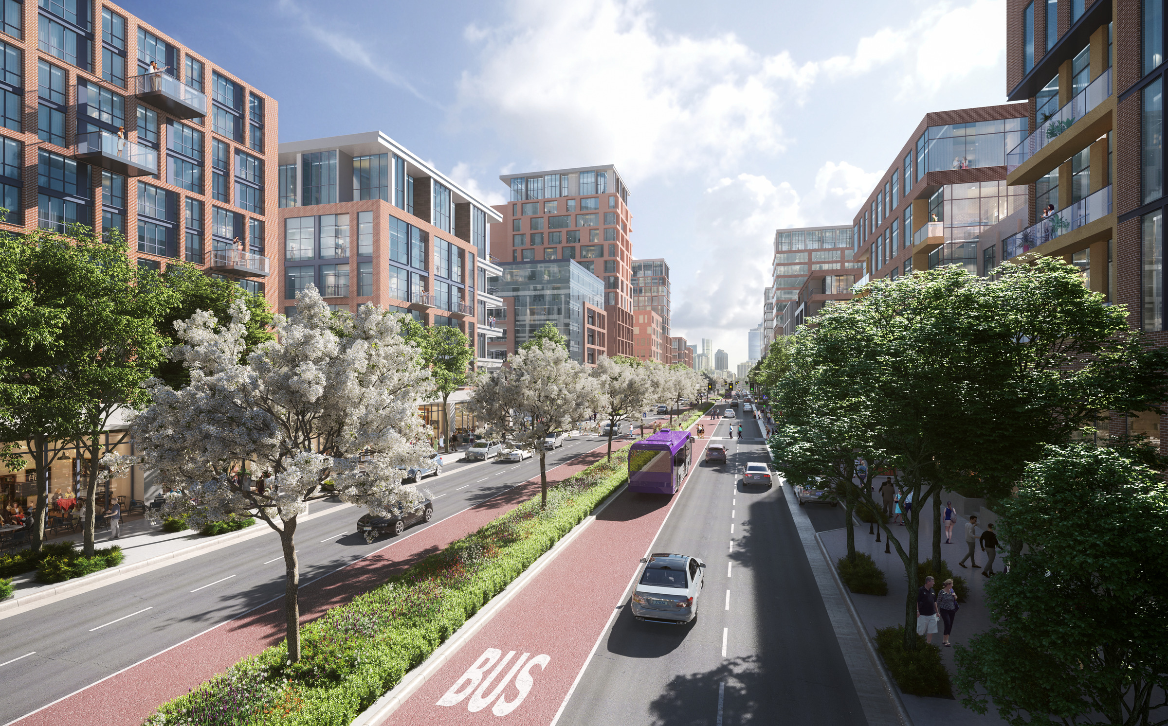
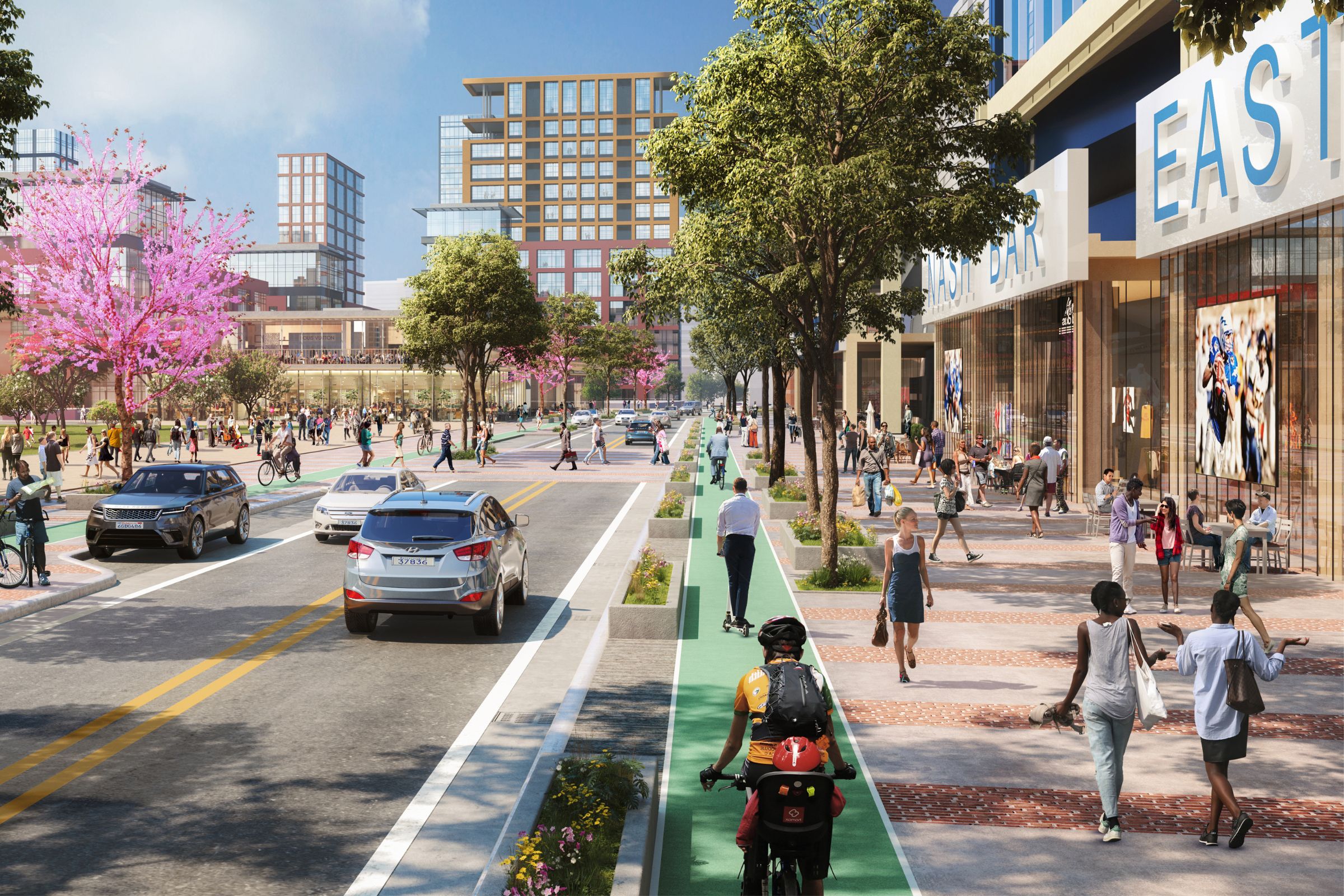
    The centerpiece of the new street and block system proposed for the East Bank will be a multi-modal boulevard that  will function as its primary transportation spine, linking each of the East Bank’s districts and providing connections to adjacent East Nashville neighborhoods.

    A rendering of the new boulevard that will serve as a central spine through the new Nashville East Bank, including wide pedestrian sidewalks, bike lanes, and dedicated bus lanes.

    The boulevard represents a new way of thinking about Nashville’s transportation infrastructure, functioning as:

    • A modern and complete multi-modal mobility option that brings together transit, pedestrians, and cars in one cohesive and continuous north-south corridor
    • A community connector that not only links employment centers and housing within the East Bank, but also connects diverse and economically disadvantaged neighborhoods on both sides of the river
    • A first-class address for a wider variety of new mixed-use development
    • A development catalyst and job creator that activates previously inaccessible parcels and will generate an estimated 50,000-plus jobs at build-out


    Designing for Long-Term Community Resilience

    “Employing nature-based resilience and green/blue infrastructure solutions” 

    The epic floods of May 2010 shattered nearly every rainfall record conceivable in Nashville. According to the National Weather Service, 13.57 inches of rain fell during a 36-hour period. Nearly 11,000 properties were damaged or destroyed in the flood, causing more than $2 billion in private property damage.

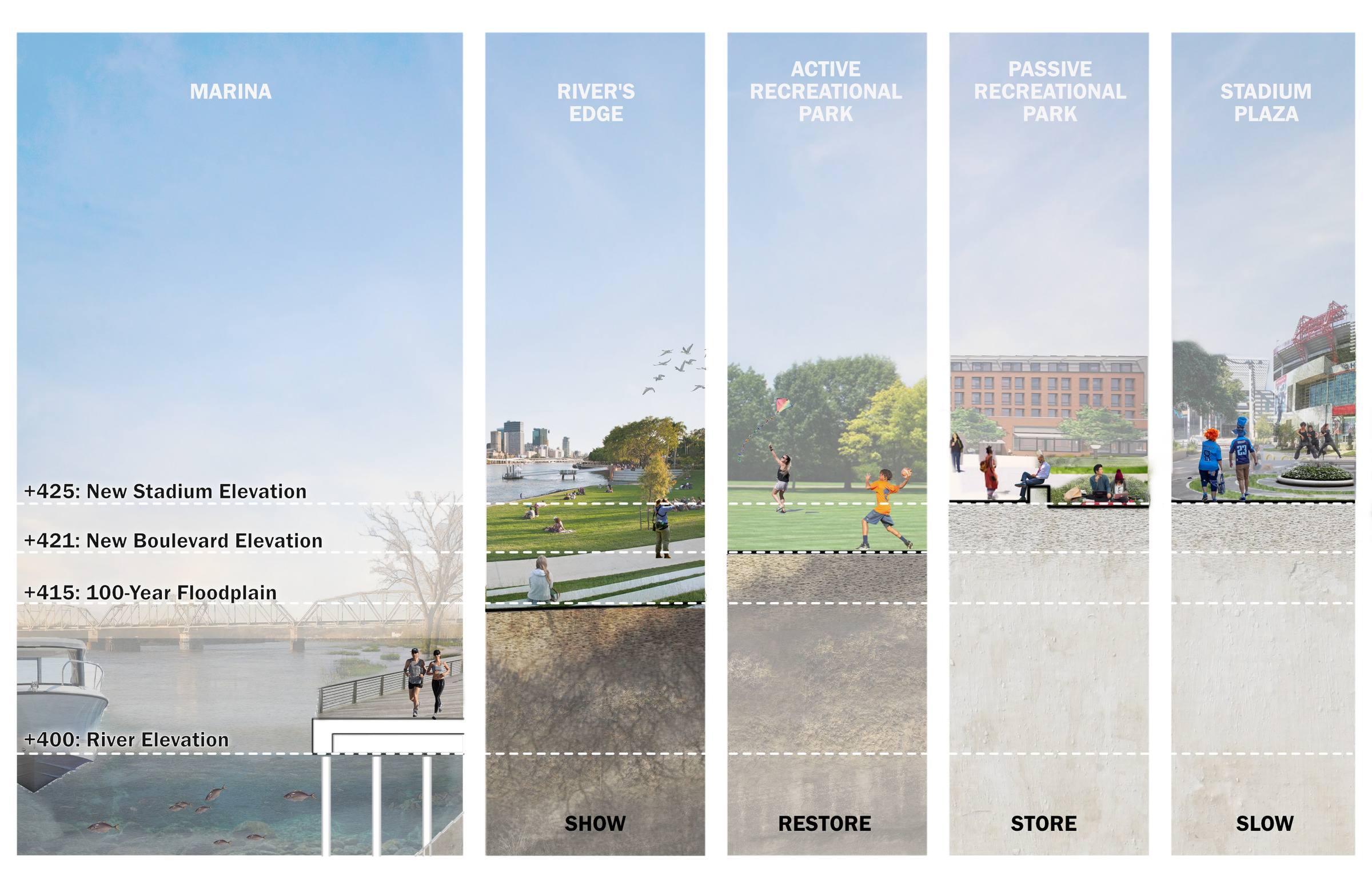
    The storm was the only one to crest higher than the 100-year storm elevation since the full regulation of the Cumberland River began in 1967. Perkins Eastman worked with Metro Water to craft a district-wide approach to resilience that can deal with water in a manner appropriate to the local conditions and integrate the treatment of water with placemaking, landscape design, and development. The framework takes a comprehensive approach to manage local stormwater interactions and balance the frequency of riverine flood inundation with associated risks and opportunities. It focuses on several key tactics, ensuring a balanced approach to land alteration by managing cut/fill ratios and considering the hydraulic flow during riverine flooding to improve water movement and reduce prolonged inundation. The plan maximizes the potential of passive open spaces in the Riverfront Park and Central Park to establish an open-space network.

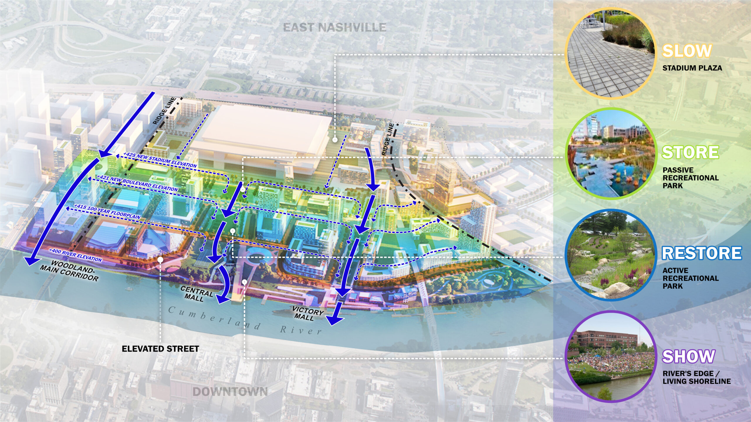
    This performative landscape follows a step-by-step approach, involving the slowing down of runoff, storing stormwater, restoring water quality, and ultimately discharging and showcasing water:

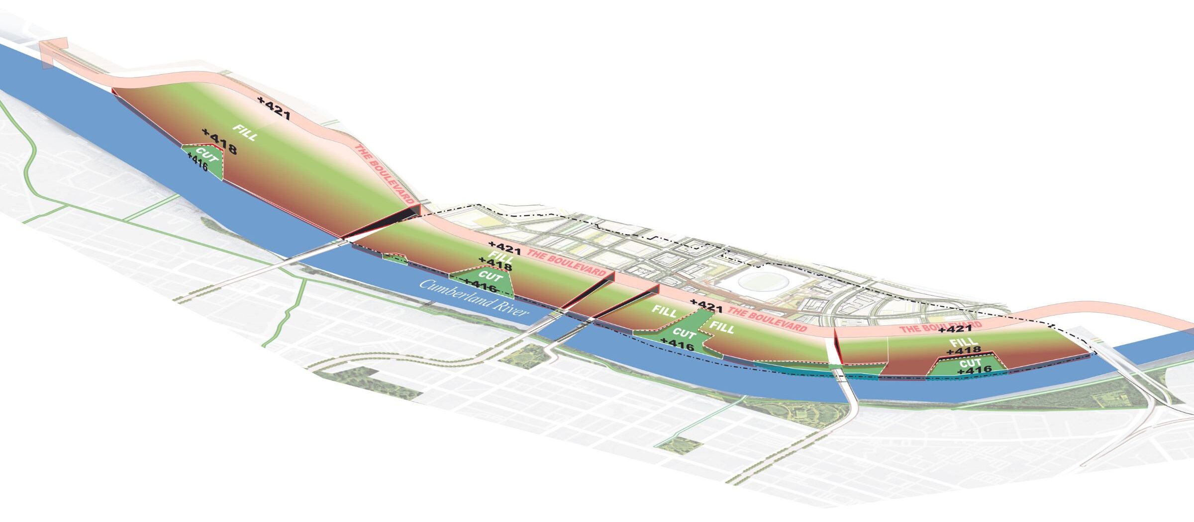
    A rendering of the Cumberland River and the Nashville East Bank shows a "cut and fill" concept where some areas will be built up above historic flood levels, while other areas will be cut out to channel stormwater back into the river in a more orderly fashion.

    This “cut and fill” concept represents areas that are strategically built up, while others are cut in order to channel excess stormwater in a more orderly fashion out into the river.


    A rendering of a planned park on Nashville's east bank shows how it will also be used for stormwater management.

    The “cut” area to be used as a stormwater management park. The river’s edge is to be developed as a wetland area, showing the river as a great asset to the city.

    A district-scale approach enables the implementation of nature-based resilience measures on the East Bank. Development parcels are elevated as levees to protect inner land, while park spaces effectively attenuate flood and stormwater. This comprehensive strategy ensures that nature-based solutions work harmoniously to enhance flood protection, a feat achievable only through district-scale planning and design.

    A diagram of the new Nashville East Bank plan illustrated the district-scale approach to climate resiliency, indicating areas that will first slow stormwater, then store it, then cleanse the water through parks and wetlands before sending it back out into the river.


    An elevation study for Nashville East Bank shows how the new development will double as infrastructure to manage flood waters.


    New Riverfront Greenway

    “Realizing a long-sought city goal to open it up to the Cumberland”

    The greenway concept involves the development of a connected trail system that links neighborhoods and provides direct access to the river, expanding upon the existing Nashville Greenway. Each district will offer recreational opportunities, floodable landscapes, and maritime activities, allowing residents and visitors to engage in outdoor pursuits and enjoy the natural beauty. The Greenway’s programming and character will be tailored to the unique attributes of each district, resulting in a diverse yet interconnected network of trails. The result will be a cohesive and accessible trail system that promotes physical activity, enhances livability, and strengthens community bonds throughout the city.

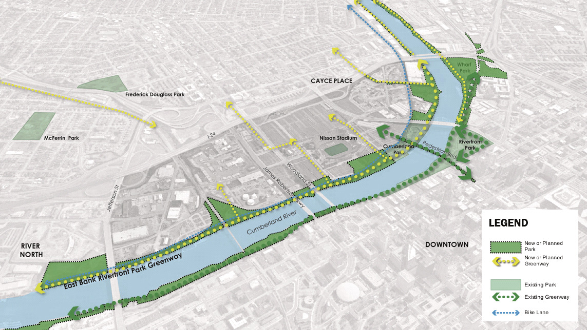
    A central feature of the new East Bank will be a riverfront greenway, a long-cherished goal of the city’s park advocates. The greenway will be the central thread of a two-mile-long riverfront park connecting the East Bank’s various districts.

    A map diagram illustrates how a new greenway branch will connect the Nashville East Bank’s grid and city-wide trail system along the under-utilized riverfront.

    A new greenway branch will connect East Bank’s grid and city-wide trail system along the under-utilized riverfront.


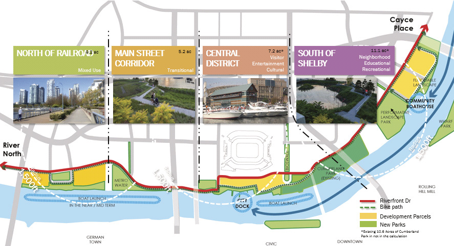
    A diagram of the Nashville East Bank illustrates the water plan along Riverfront Drive and the new greenway extension.

    The water plan along Riverfront Drive and the new greenway extension.


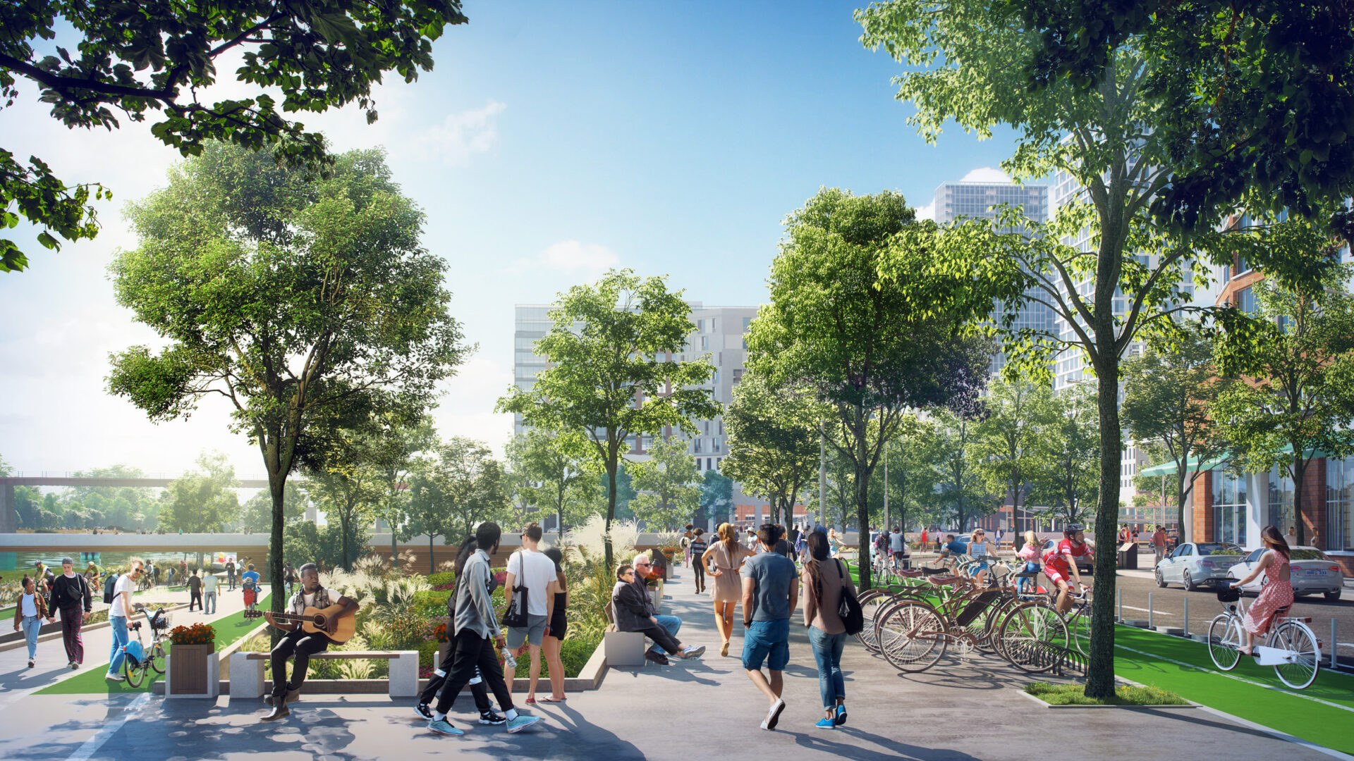
    An illustration of the new greenway with a dedicated bike lane on Nashville's East Bank
    An illustration of the new greenway with a dedicated bike lane.


    A Water Plan for the Cumberland

    “Furthermore, the river serves as a transportation route, offering an alternative mode of travel.” 

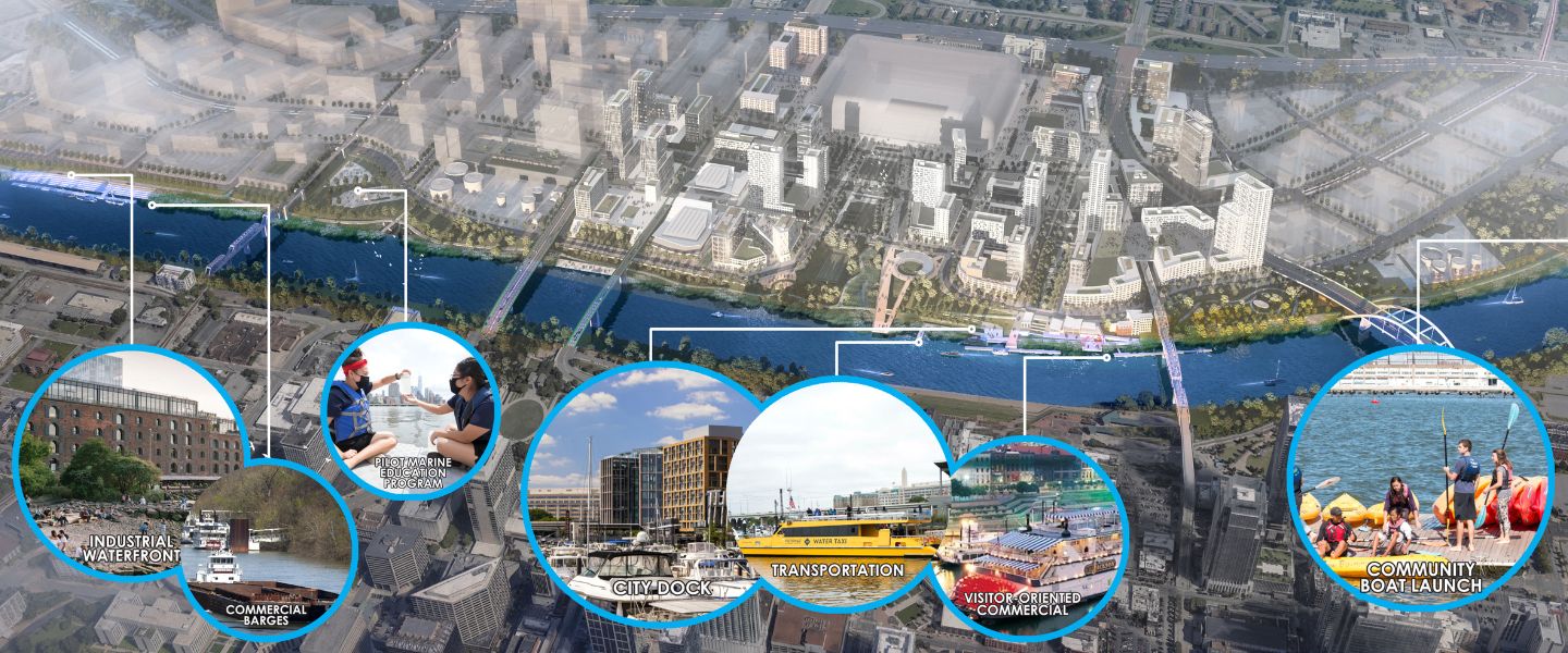
    Nashville East Bank rendering of the recreational and transportation dock.

    The city will have its first recreational and transportation dock on the Cumberland River under the East Bank development plan, which will serve as an extension of the existing Cumberland Park and pedestrian bridge.

    A central feature of the Imagine East Bank Plan is to engage the Cumberland River. This includes new access to the river and new programming in—not just by—the river. The plan sees the Cumberland River offering a broader range of opportunities for recreational, educational, entertainment, and leisure as well as visitor-oriented activities on the water. These activities will in turn draw a broad cross-section of Nashvillians and visitors to the water, create exciting new possibilities for riverfront development, and build a constituency for climate-resilient infrastructure. The presence of water activities on the Cumberland River will create a dynamic and inclusive environment that brings people together, enhances community well-being, and enriches the overall quality of life in Nashville.

    A water plan for Nashville's East Bank represents the myriad activities that will be available with the new development.


    Imagine East Bank

    To ensure the new East Bank does not develop into an isolated precinct separate from the rest of the city, the plan incorporates several strategies:

    • Recasting two of the existing car-dominated bridges across the Cumberland River to accommodate pedestrians and bike lanes
    • Adding new cross-river capacity with a new bridge that will connect the East Bank to Murfreesboro Pike
    • Expanding connections to adjacent East Nashville neighborhoods east of I-24
    • Creating 12 new streets to provide new access to the riverfront for residents of both the East Bank and East Nashville
    A map illustration showing the new grid of streets that will flow through Nashville's East Bank.

    The East Bank’s proposed new grid system

    A rendering of the new Nashville East Bank shows how a new central boulevard will connect districts in the East Bank and its adjacent neighborhood districts.
    A new central boulevard will connect districts in the East Bank and its adjacent neighborhood districts.


    A New Multimodal Circulation System

    The East Bank presents—for the first time—the opportunity to create a true multi-modal transportation network, providing for the needs of pedestrians, transit, bikes, and vehicular circulation.

    The key principles are to:

    • Create a walkable street grid for each of the East Bank’s districts
    • Create a redundant set of multi-modal routes linking up all of the districts
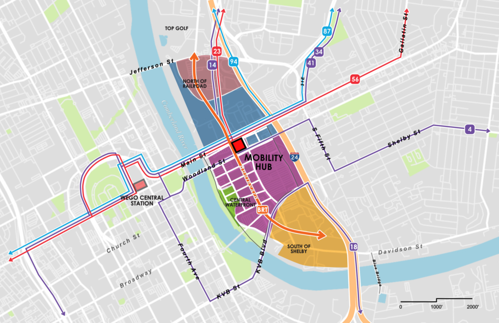
    • Establish a new East Bank Mobility Hub that connects WeGo bus lines, offering convenient access for commuters, accommodating diverse service scenarios, and providing bike parking and service facilities
    • Propose a new street and block system for each of the four districts that works with existing property ownership patterns and is built around a hierarchy of walkable neighborhood streets
    • Link the four districts together with a central boulevard, a modern, multi-modal option that brings together transit, pedestrians, and cars in one cohesive and continuous north-south corridor.
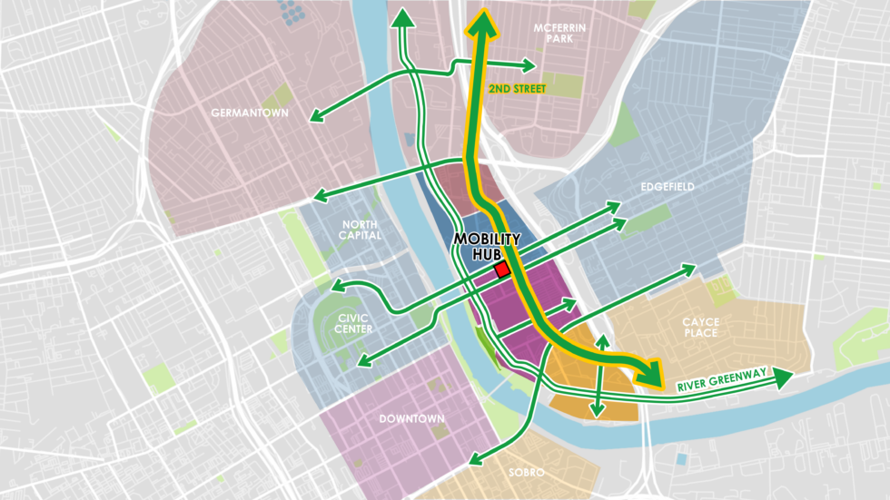
    A rendering of the dedicated bike lane along Second Street in Nashville's new East Bank.

    Second Street will accommodate 2.4 miles of dedicated bike lanes, weaving through East Bank’s four districts, that will also connect to surrounding neighborhoods in East Nashville.

    A map illustrate new Bus Rapid Transit lines and a mobility hub in Nashville's East Bank. A map illustrates new Bus Rapid Transit lines, bike paths, and a mobility hub in Nashville's East Bank.

    Maps illustrate new Bus Rapid Transit lines, bike and pedestrian paths, and a mobility hub in Nashville’s East Bank. 


    Key Places

    “Knitting the stadium to the neighborhood”

    Attention to ground-level uses and the scale of the new stadium will help ensure that it’s a good neighbor with the surrounding district.

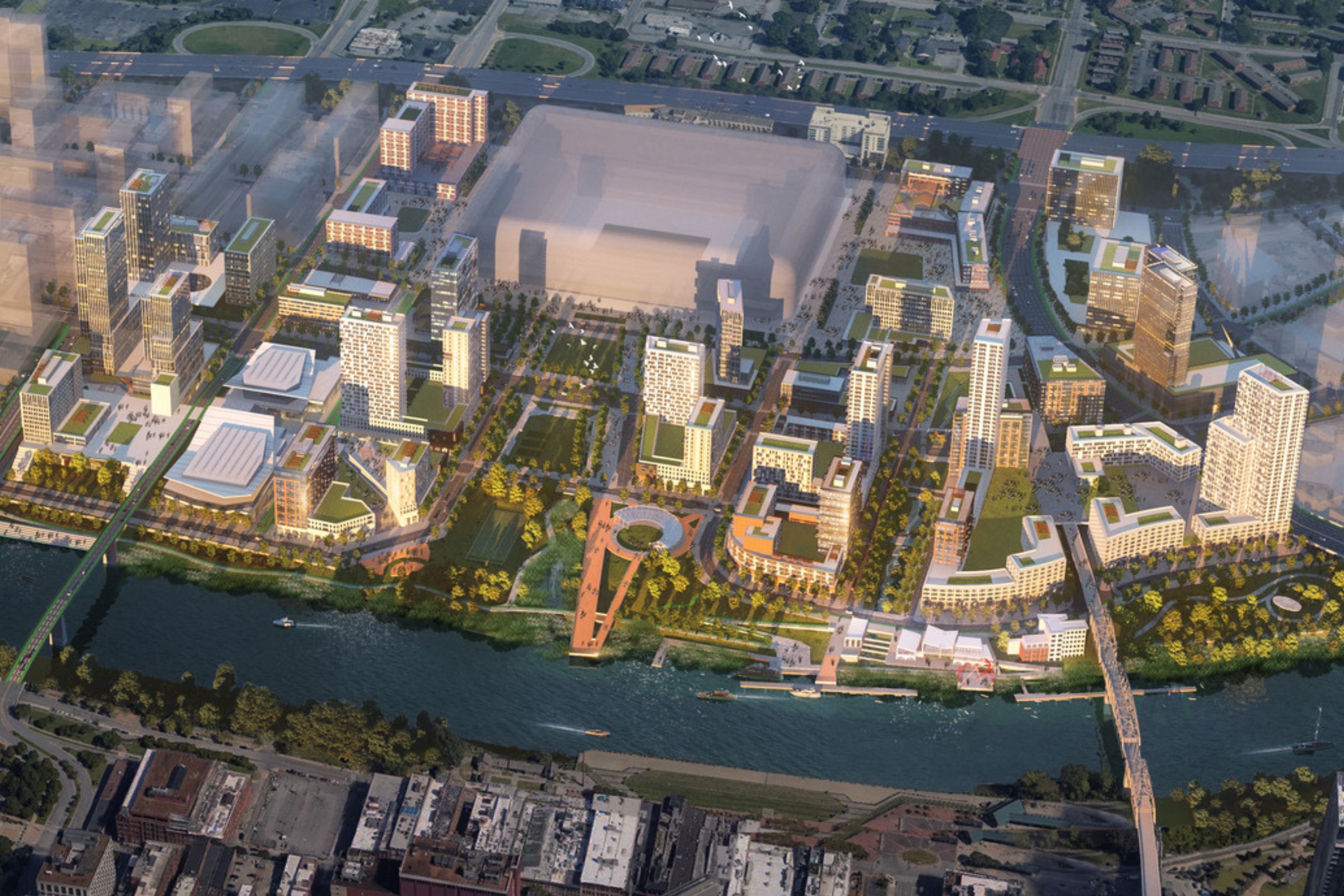
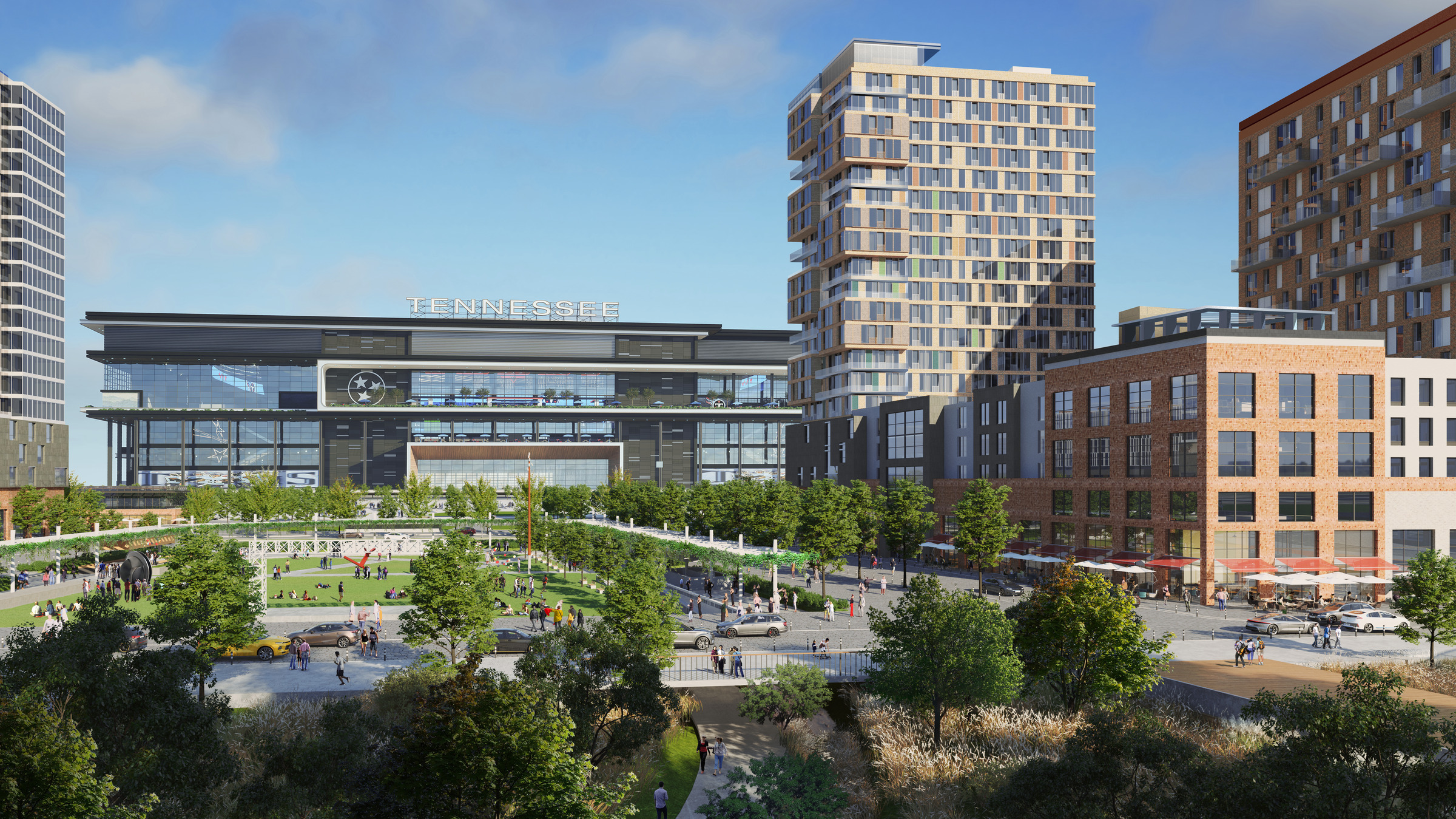
    An aerial rendering of Nashville's East Bank, with the new NFL stadium at its center.


    A map diagram depicting the network of parks the lead from the new Nashville NFL Stadium to the Cumberland River waterfront


    Stadium Plaza

    The Stadium Plaza not only acts as an additional venue for major stadium events but also holds significance as the symbolic launching point for monumental gatherings. Its design seamlessly integrates with the above-ground spaces of neighboring buildings, creating a tranquil and symbolic setting for residents and visitors alike.

    The park has an underground section that incorporates water storage facilities, promoting sustainable water management practices and adding an eco-friendly element to the overall design. This holistic approach ensures that the Stadium Plaza contributes not only to the success of events but also to the area’s long-term environmental sustainability.

    A rendering of Stadium Plaza to be built outside Nashville's new NFL Stadium.

    A rendering of Stadium Plaza, to be built outside Nashville’s new NFL Stadium.


    Central Park

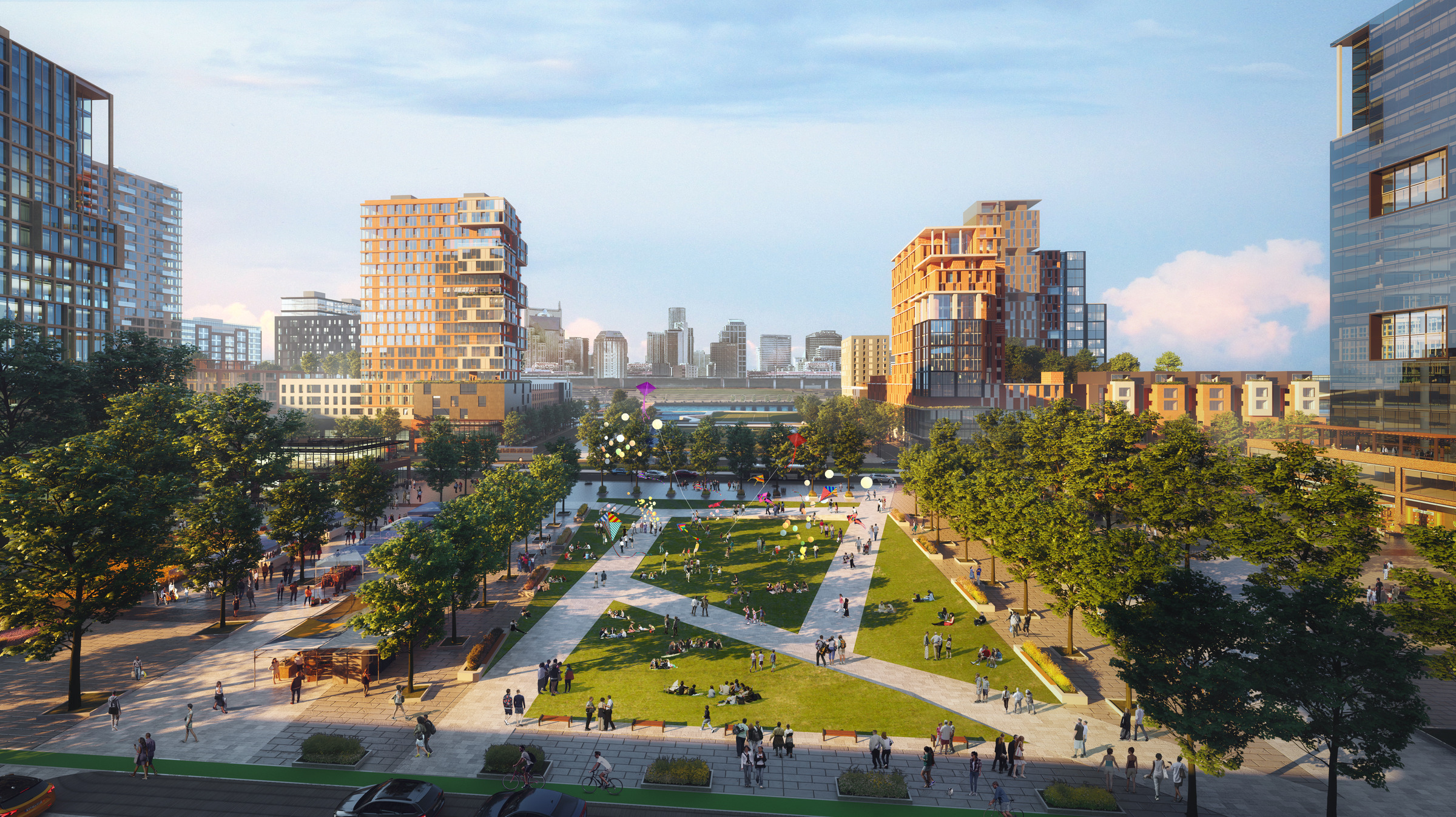
    Central Park is a versatile public space designed to host a wide range of events. With adaptable amenities, stages, and facilities, it aims to become a symbolic destination in Nashville, showcasing the city’s most significant events. The park will serve as a vibrant hub for cultural, entertainment, and community gatherings, enhancing the allure of Nashville’s urban landscape. And like the adjacent Stadium Plaza, an underground level contains an advanced water management system, storing and treating water underground and facilitating its flow to the river.

    A rendering of the new Central Park in Nashville's East Bank development plan -- a combination of grass, trees, and walking paths.


    Victory Park and City Dock

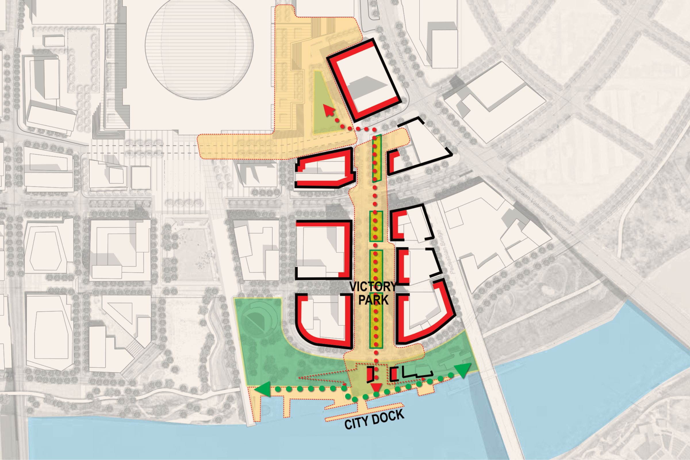
    After the stadium’s relocation, Victory Way, an emblematic open space spanning 700 feet in length and 140 feet in width, will undergo a significant transformation, though its surrounding large trees will be preserved. This remarkable area will be repurposed into a bioswale, serving the dual purpose of purifying and discharging the encompassing rainwater as it flows from the boulevard towards the Cumberland River.

    A map diagram of the new Victory Park, which will connect the new NFL stadium in Nashville's East Bank to the riverfront.

    Victory Park will connect the new NFL stadium in Nashville’s East Bank to the riverfront.


    A rendering illustrates Victory Park as it leads down from the new stadium in Nashville's East Bank to the Cumberland River.

    Victory Park will act as a bioswale to filter stormwater as it flows from the new stadium to the Cumberland River.